- What are the main geographical regions of Colombia?
Colombia is primarily divided into six natural regions: the Andean Region, the Pacific Region, the Caribbean Region, the Orinoquía Region (Eastern Plains), the Amazon Region, and the Insular Region. Each boasts unique landscapes and ecosystems, from high mountain ranges to vast river basins and islands.
- How do the Andes Mountains impact Colombia's climate and biodiversity?
The Andes Mountains significantly influence Colombia's climate by creating diverse altitudinal thermal floors, leading to varied temperatures and microclimates. This topographical complexity fosters extraordinary biodiversity, supporting numerous endemic species and distinct ecosystems across its three cordilleras.
- Where is the Amazon Rainforest located on Colombia's geographical map?
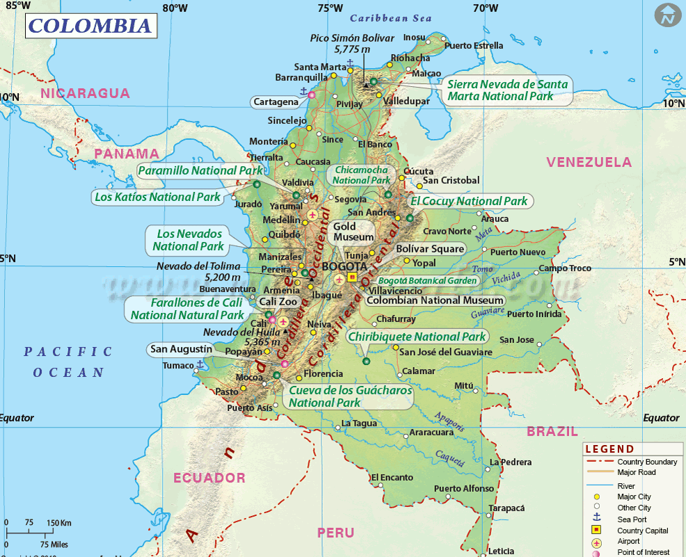
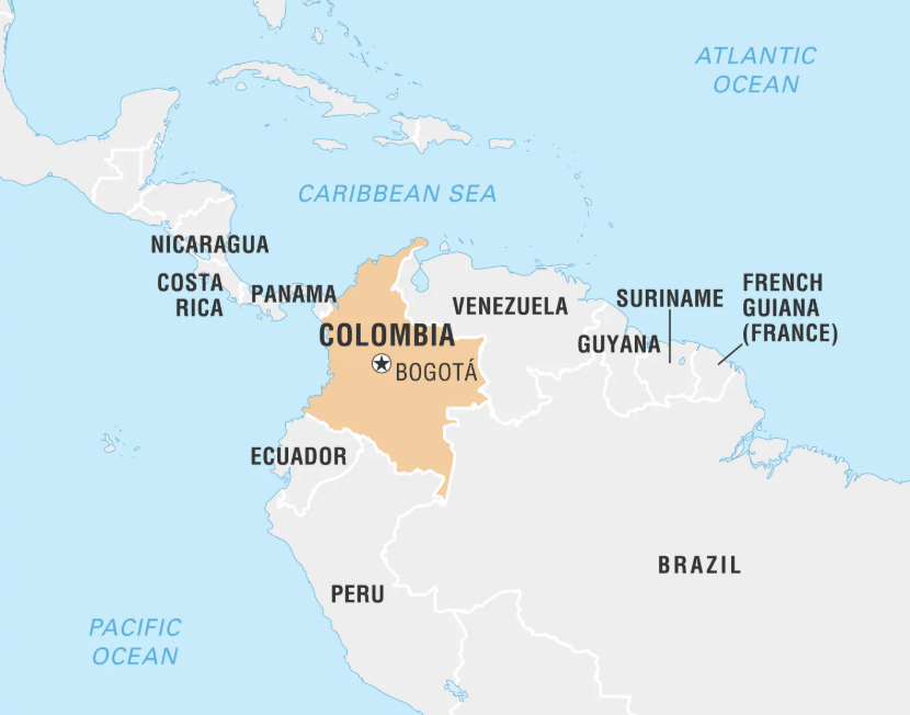
On a Colombia geographical map, the Amazon Rainforest primarily occupies the southeastern part of the country, bordering Peru, Ecuador, and Brazil. This vast region is characterized by dense tropical forests, numerous rivers, and is crucial for global biodiversity and climate regulation.
- What are the key rivers visible on a Colombia geographical map?
The most prominent rivers on a Colombia geographical map are the Magdalena River, the Cauca River, and the Atrato River, which all flow north towards the Caribbean Sea. In the east, the Orinoco and its tributaries, and in the south, the Amazon and its tributaries, are also key features.
- How does Colombia's coastline differ between the Caribbean and Pacific?
Colombia's Caribbean coastline is characterized by drier tropical climates, sandy beaches, and vibrant port cities like Cartagena. In contrast, the Pacific coastline is wetter, densely forested with mangroves, and less developed, known for its incredible biodiversity and indigenous cultures.
- What are the highest peaks shown on Colombia's topographical maps?
Colombia's highest peaks, Sierra Nevada de Santa Marta's Pico Cristóbal Colón and Pico Simón Bolívar, are unique as they are coastal mountains. They stand over 5,700 meters, making them the world's highest coastal peaks, dominating the northern Caribbean landscape on topographical maps.
- Why is Colombia considered megadiverse geographically?
Colombia's megadiversity stems from its unique geographical position at the convergence of several biomes: the Andes Mountains, Amazon Rainforest, Pacific and Caribbean oceans, and the Orinoco plains. This creates an unparalleled variety of ecosystems, climates, and species richness found almost nowhere else globally.
Embark on a virtual journey through Colombia's stunning geographical landscape. Our comprehensive guide unpacks the diverse terrain from the towering Andes Mountains to the lush Amazon Rainforest and both the Caribbean and Pacific coastlines. Discover how these varied features influence local climates biodiversity and cultural regions. Ideal for modern explorers and digital nomads aged 20 45 this article provides essential insights into understanding Colombia's unique topography for travel research or educational purposes. Navigate the intricate details of river systems plains and mountain ranges ensuring you are fully informed for your next adventure or study. This trending resource uses an informational and navigational approach making it perfect for quick mobile-friendly discovery of Colombia's incredible natural wonders.
- What are the major geographical features of Colombia? - Colombia boasts diverse features including the Andes Mountains, the Amazon Rainforest, vast Caribbean and Pacific coastlines, and major rivers like the Magdalena. These elements combine to create a landscape of incredible topographical variety and distinct climate zones across its six natural regions.
- How do the Andes Mountains shape Colombia's landscape? - The Andes Mountains divide Colombia into three cordilleras, dramatically influencing its landscape. They create high-altitude plateaus, deep valleys, and diverse thermal floors, leading to a rich variety of ecosystems and microclimates. This mountainous backbone defines much of Colombia's central geography.
- Where is the Amazon Basin located on a map of Colombia? - On a geographical map of Colombia, the Amazon Basin is situated in the southeastern part of the country. This expansive region is characterized by dense rainforest, crisscrossed by numerous rivers, and forms a critical part of the larger Amazon ecosystem, sharing borders with Brazil, Peru, and Ecuador.
- Which major rivers flow through Colombia? - Colombia is home to several significant rivers. The Magdalena and Cauca rivers are vital for transportation and agriculture, flowing northward towards the Caribbean Sea. The Atrato River serves the Pacific region, while tributaries of the Orinoco and Amazon rivers traverse the eastern and southern plains respectively.
- What distinguishes Colombia's Caribbean and Pacific coasts? - Colombia's Caribbean coast is known for its drier, sunny climate, beautiful sandy beaches, and vibrant cultural cities. In contrast, the Pacific coast is much wetter, characterized by dense rainforests, mangroves, and rich biodiversity, making it a more remote and ecologically pristine region.
- What is the highest point in Colombia according to geographical maps? - According to geographical maps, the highest points in Colombia are Pico Cristóbal Colón and Pico Simón Bolívar, located in the Sierra Nevada de Santa Marta. These twin peaks are unique for being the world's highest coastal mountains, standing majestically just a short distance from the Caribbean Sea.
- Why is Colombia's geography so diverse? - Colombia's exceptional geographical diversity stems from its unique position where the Andes Mountains meet the Amazon rainforest, the Pacific and Caribbean oceans, and the Orinoco plains. This convergence creates a multitude of distinct ecosystems, climate zones, and an extraordinary level of biodiversity unmatched globally.
Ready to unlock the geographical secrets of Colombia? This guide cuts through the noise to deliver exactly what you need to know about Colombia geographical map. From towering peaks to sprawling rainforests and stunning coastlines, Colombia offers a world of discovery. Whether you are planning a trip, researching a project, or just curious, understanding its unique topography is key. Get ready to explore a nation where every turn of the map reveals a new natural wonder.
Frequently Asked Questions
Where are the most prominent geographical features on a Colombia map?
On a Colombia geographical map, the most prominent features are the majestic Andes Mountains running north to south, the expansive Amazon Rainforest in the southeast, and the distinct Caribbean Coast in the north.
How can I use Local MAPs to understand Colombia's diverse geography?
Pull up your preferred mobile Maps app to verify real-time hours, as peak weekend times fill up fast. Use the satellite view to visually explore Colombia's varied terrain, from the rugged Andes to the flat eastern plains, and identify major rivers like the Magdalena.
What are the best times to explore different geographical regions of Colombia?
For the Andean regions, December to March and July to August offer drier weather. The Caribbean coast is best from December to April. For the Amazon lowlands, plan your visit during the drier months of July to November.
Quick Local Guide:
- Geographical Feature: Andes Mountains | Region: Western and Central Colombia
- Geographical Feature: Amazon Rainforest | Region: Southeastern Colombia
- Geographical Feature: Caribbean Coast | Region: Northern Colombia
- Geographical Feature: Pacific Coast | Region: Western Colombia
- Geographical Feature: Orinoco Plains (Llanos) | Region: Eastern Colombia
- Geographical Feature: Magdalena River Valley | Region: Central Colombia
Colombia's geography is defined by its majestic Andes Mountains diverse Amazon and Orinoco basins extensive Caribbean and Pacific coastlines and numerous vital river systems like the Magdalena and Cauca. It boasts a wide array of climates and ecosystems making it one of the most biodiverse nations globally.


Colombia Political Map Physical Of Detailed With Major Cities South Blue Green Atlas The Geography Relief Topographic At Sherley Falk Blog High Labeling 2BXNN1C.


Detailed Map Of Colombia MICHELIN Bogot HSIWA Political And With Roads Major Cities Small Large Terrain Geography Now At Dominique Ortega Blog Physical Wall By Graphiogre Mapsales Colombiaphy C Sar Gaviria Trujillo President Britannica Features Locator.


Geography Now Colombia At Dominique Ortega Blog Physical Map Highly Detailed Vector Format All Relief Forms Regions Big Cities 188053912 Of Political South America Mapsland Alchetron The Free Social 368C38FF C377 4534 A3B2 EE60EE134FE Resize 750 Colombian Large.


Colombian Map Topo 2K Marco Polo On Twitter Mapa De Colombia Mapas Marquesinas Casas Of South America Physical 3D Render Topographic Color Border Riohacha Wikip Dia 960PX Relief Location.


Colombia S Coffee Production Plunges As Relentless Rains Cripple Map Colombian Het Roodkapje En Symbolen Uitgelegd Physical Features Natural Resources Kids Britannica Homework Help 62402 004 562efa14 Geography.


Colombia Median Age 1960 2026 True Size On The Map 2025 Qmg Col Y25 Q01 Mapbiomas COLECCION3 Detailed Insights Geography Population And Key Facts 1000 F 859303300 DS4 Paginas Blancas Country Profile Nepal 128627161 Bbcmp.


Columbia Map Colombia Physical Political Topography Roads Bonus Etsy Australia Il 1FUQ Hd Archivo Provinces Of Colombian 2026 Svg Wikipedia La 1920PX 2026 Geography And Environment 2166504 Orig.